info@caliylark.com
Surveying Equipments
Surveying Equipments
Terrestrial 3D scanners are advanced ground-based scanning systems designed to capture high-resolution spatial data of large-scale environments, objects, and infrastructures. Operating from fixed positions on land, these scanners utilize LiDAR (Light Detection and Ranging) or laser pulse technologies to perform precise, non-contact surface mapping over extended distances. Ideal for surveying vast outdoor areas or complex industrial settings, they can generate highly detailed three-dimensional point clouds that form the basis for accurate models, simulations, and analyses.
At Caliylark Technologies, our terrestrial 3D scanners are built for demanding field applications where accuracy, range, and efficiency are paramount. With advanced targeting, rapid scanning speeds, and seamless integration into design and BIM workflows, our scanners allow engineers, surveyors, and architects to visualize environments in true-to-life detail, all while operating in a wide range of environmental conditions.
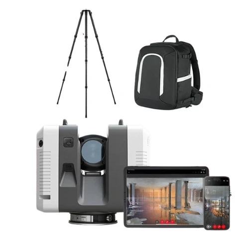
Key Features:
- Long-range laser scanning, capturing data from tens to hundreds of meters
- High-density point cloud generation with sub-centimeter accuracy
- Rugged and weather-resistant housing for field reliability
- Automatic registration and alignment of multiple scans
- Advanced GPS and IMU integration for georeferenced data capture
- Intuitive interfaces with real-time visualization and remote control options
Benefits :-
Terrestrial 3D scanning significantly enhances the precision and speed of surveying and documentation processes. Unlike traditional measurement techniques, which are time-consuming and prone to manual error, terrestrial scanners offer a highly automated, contactless, and detailed data acquisition method. This allows for quicker site assessments, better-informed planning, and higher safety standards—especially in hazardous or inaccessible areas.